
Marine GPS Chart Plotter

Terry Du
Contact person
Basic Information
Marine GPS Chart Plotter, marine GPS, Chart Plotter, marine GPS plotter, marine GPS navigation, Works with C-map Max NT Chart
FEATURE:
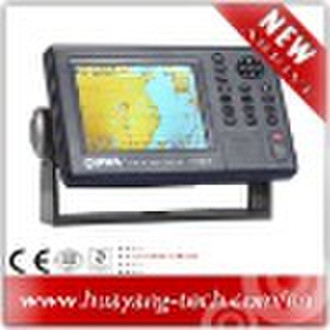
1)High resolution 5.6 inches day-view LCD display chart plotter2)Works with C-map Max NT Chart (SD) and Onwa K-Chart3)Quick chart drawing speed4)Proximity waypoint alarm5)Versatile display modes including: -Course Plot - Nav Data - Steering Display - Highway6)High performance GPS receiver7)User SD card to save and transfer waypoint, track, route memory8)Course plot in North-up, Course-up or Waypoint Up9)Tide Table10)Goto Track let you retrace your path in both directionsSPECIFICATIONSPlotter Characteristics1.Display5.6-inches color TFT day-view LCD 320 × 240 pixels2.ProjectionMercator projection3.Map Scale5m to 800 nm4.Plot Interval1s to 99h or 0.01nm to 9.99nm5.Presentation ModeNorth Up, Bow Up, Waypoint Up6.Track Memory30,000 point automatic track log: 15 saved track (up to 2,000 track points each) let you retrace your path in both directions7.Waypoint Memory15,000 waypoints with name8.Route Memory30 reversible routes with up to 200 points each, plus MOB and Track Navigation or Goto Track modes9.AlarmXTE, Anchor Drag, Arrival, Speed, Voltage, Proximity, Waypoint and Time10. Nav Data Input/OutputInput:$--BWC, $--BWR, $--DBT, $--DPT, $--GGA, $--GLL, $--HDG, $--HDM, $--HDT, $--MDA, $--MTW, $--RMA, $--RMB, $--RMC, $--TLL, $--TTM, $--VDR, $--VHW, $--VTG, $--WPL, $--ZDAOutput:$--AAM, $--APB, $--BOD, $--BWC, $--GGA, $--GLL, $--RMB, $--RMC, $--VTG, $--XTE, $--ZDAOutput for autopilot:$--AAM, $--APB, $--BOD, $--VTG11. Proximity Waypoint10 proximity waypointPALLETE1.DaylightExposed to sunlight2.NightIn dark environment3.NOAAPaper chart colorMemory1.External SD CardsTwo SD Cards slot for C-map MAX and User SD memory card2.Internal MemoryBuilt-in Onwa K-ChartGPS Receiver Characteristics1.AccuracyPosition: <15 meters(95%) without S/AVelocity: 0.1 meter/sec without S/ATime: 100ns synchronized to GPS time2.AcquisitionCold start: 60 seconds averageWarm start: 45 seconds averageHot start: 15 seconds average3.DynamicsAltitude: 18,000m MaxVelocity: 500 m/sAcceleration: 4g Max4.DatumWGS 84Physical1.Size228mm(H) 138mm(W) 79mm(D)2.Weight0.9kgEnvironment1.Temperature-15 to + 55 (Display unit)-25 to + 70 (GPS antenna)2.Water proofingDisplay unit: IPX5Antenna unit: IPX6Power Supply1.Power supply10.5 to 35 VDC2.Current drain0.5A at 12V; 0.3A at 24VEquipment List (Standard)1.Display unit2.Antenna unit with 10m cable3.Operator manual4.Installation materials5.Standard spare parts
Payment term
Documents Against Acceptance
Documents Against Payment
Letter of credit
Telegraphic transfer
MoneyGram
Western Union

-
Payment Methods
We accept:


